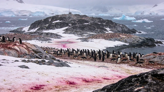
NASA's Landsat 8 satellite and drone surveys have enabled researchers to monitor Adélie penguin colonies on the Danger Islands by analyzing the color of their guano, offering new insight into how changing sea ice may affect Antarctic food webs
Remote sensing has become a powerful tool for tracking ecological change in some of the world's most inaccessible regions. On Antarctica's Danger Islands, researchers have combined satellite imagery with field and drone observations to monitor Adélie penguin colonies and investigate how their diets respond to environmental shifts.
Tracking Penguins from Orbit
Scientists used data from NASA's Landsat 8 satellite, which observes Earth in visible and infrared wavelengths from an altitude of approximately 705 kilometers, to identify penguin colonies by the distinctive color of their guano. The presence of pinkish-orange stains on the ice and rocky terrain of islands such as Heroína and Beagle indicates a diet rich in krill, a small crustacean that forms a key part of the Antarctic food web.
These color signatures are visible in images acquired on January 22, 2023, and allow researchers to estimate colony locations and sizes without direct ground access. The approach is particularly valuable in the remote and hazardous environment of the Antarctic Peninsula, where logistical challenges often limit fieldwork.
Dietary Clues in Guano Color
The coloration of Adélie penguin droppings provides a proxy for dietary composition. Krill, which feed on algae containing pink pigments, impart a reddish hue to penguin guano. By mapping these stains from space, scientists can infer periods when krill dominate the penguins' diet, as opposed to times when fish or other prey are more prevalent and produce differently colored waste.
To validate and refine these remote observations, researchers have also deployed drones to capture high-resolution images of penguin colonies. These aerial surveys help confirm the presence and density of nesting birds, and enable the collection of guano samples for laboratory analysis. Such samples reveal not only recent dietary patterns but also longer-term changes in food availability linked to sea ice conditions.
Sea Ice, Food Webs, and Environmental Change
Adélie penguins are considered sensitive indicators of Antarctic ecosystem health because their foraging success depends on the abundance of krill, which in turn is influenced by the extent and duration of sea ice. As sea ice patterns shift due to climate variability, the structure of the region's food web may be altered, affecting both penguin populations and the broader marine community.
Satellite-based monitoring enables researchers to track these changes over large spatial and temporal scales. By correlating guano color data with sea ice records and direct dietary analysis, scientists are building a more detailed picture of how environmental change is reshaping Antarctic ecosystems. This approach complements other remote sensing efforts, such as the identification of possible ancient impact craters in polar regions, including a recently reported structure in northern Quebec (evidence of a potential impact site), highlighting the expanding role of satellite data in Earth and planetary science.
Limitations and Future Directions
While satellite imagery provides a valuable overview, it cannot resolve individual penguins or distinguish between closely spaced colonies. Cloud cover, snow, and seasonal lighting conditions can also obscure surface features, introducing uncertainty into population and dietary estimates. Ground and drone surveys remain essential for calibration and for collecting biological samples that reveal details invisible from orbit.
Ongoing integration of satellite, aerial, and field data is expected to improve the accuracy of penguin monitoring and clarify the links between sea ice dynamics, prey availability, and population trends. As Antarctic environments continue to change, these methods will be critical for assessing the resilience of species like the Adélie penguin and for informing conservation strategies.
Satellite remote sensing relies on the detection of electromagnetic radiation reflected or emitted from Earth's surface. Instruments such as those aboard Landsat 8 record data in multiple spectral bands, allowing scientists to distinguish between different surface materials and biological signatures. In ecological studies, color variations in satellite images can indicate the presence of specific organisms or biological processes, but interpretation requires careful calibration with ground truth data to account for confounding factors such as lighting, weather, and surface composition.