Curiosity has drilled into Basque Lakes in Gale crater and is preparing mineral analysis that could reveal how this Martian rock formed and changed over time
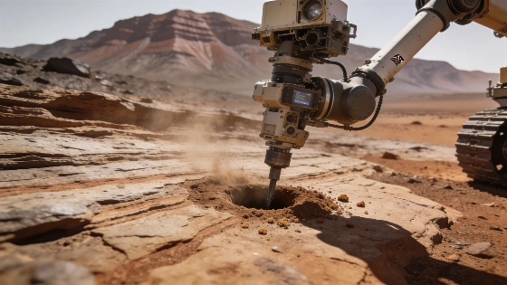
Curiosity has completed its 48th successful rock-drilling operation at a target named "Basque Lakes" in the Cache Creek quad of Gale crater. The rover is preparing the powdered sample for CheMin's X-ray diffraction analysis, followed by delivery to the Sample Analysis at Mars, or SAM, instrument. The measurements are expected to identify minerals and help determine how the rock formed and changed, but no final mineralogical result has yet been reported.
The campaign is scientifically notable because Basque Lakes represents Curiosity's first drill target above Mount Sharp's erosional supersurface, a geological boundary used to distinguish older from younger strata in the crater. That position gives the sample added context in NASA's long-running effort to reconstruct how Gale crater's environments evolved through time.
The drill site lies in the Cache Creek quad, a region named before landing after an area of geological diversity in British Columbia, Canada. That terrestrial reference includes oceanic crust, marine sediments, volcanic rocks and glacial deposits, alongside lakes with unusual chemistry that may provide useful analogies for ancient Martian environments. The comparison is contextual, however. Mineral similarities would need to be established by Curiosity's measurements rather than assumed from the shared name.
Cache Creek also carries the legacy of British Columbia's 1860s Gold Rush Trail. That history supplies the week's "cashing in" metaphor, but the rover is not searching for precious metal. Its scientific value lies in determining which minerals occupy the rock and what those minerals indicate about deposition and later alteration.
Curiosity reached the new quad after a journey lasting nearly 14 years. By late September 2026, the rover had traveled about 38 kilometers and climbed more than 1 kilometer in total elevation, taking it well beyond the rectangular planning parcels defined before landing. Each new target therefore adds local geological evidence to a much longer traverse across Gale crater.
The decision to drill followed a compact sequence of contact science. APXS was placed against the potential target to measure its surface chemistry, while MAHLI moved to about 1 centimeter from the rock to record its texture at close range. ChemCam then fired its laser at Basque Lakes, adding another composition measurement before the team committed to drilling.
Engineers also used a pre-load test to assess whether the rock was stable enough for the drill. MAHLI imaged the target again after that check. The resulting chemistry, texture and stability information supported the decision to proceed, making the drill hole the outcome of an engineering assessment as well as a geological selection.
NASA's image of the site was acquired by MAHLI on Sept. 23, 2026, during Sol 5023 of the Mars Science Laboratory mission, at 03:56:10 UTC. It shows the target after the pre-load test. The photograph documents the working surface around the hole; it does not itself reveal the mineral composition that CheMin must determine.
About 85 milligrams of drilled powder are typically directed into Curiosity's mineralogy workflow for CheMin analysis. That small quantity is sufficient for X-ray diffraction, which identifies crystalline minerals by measuring how their atomic structures scatter X-rays. The result will not be a simple visual description of the dust, but a mineralogical measurement that must be interpreted alongside chemistry, texture and the surrounding terrain.
CheMin's analysis is important because mineral assemblages can preserve evidence of the conditions under which a rock formed and the chemical changes it experienced afterward. The sample may help test whether rocks above the erosional supersurface record a different environmental history from the strata Curiosity examined lower on Mount Sharp. Any conclusion, however, will depend on the returned measurements rather than on the target's name or location alone.
The rover's limited power budget did not prevent a broader observation plan. Mastcam recorded the surrounding terrain to place the drill sample in its geological setting. ChemCam analyzed a nearby bedrock target called "Peace River" and used imaging and passive spectroscopic capabilities to inspect the new drill hole and its tailings. It also examined a jumbled deposit of blocks at the base of a nearby butte named "Cordillera."
Navcam and Mastcam continued monitoring environmental and atmospheric conditions in Gale crater. These observations do not replace the sample analysis, but they help maintain a wider record of the site while Curiosity works through the operational constraints of drilling with an aging rover. NASA's method is cumulative: chemistry, texture, mineralogy, terrain and atmosphere each constrain a different part of the geological interpretation.
The broader planetary-science context is equally important. NASA's work on local Martian materials sits alongside research into how future explorers might use planetary resources, including the earlier materials study. Curiosity's Basque Lakes sample is not a technology demonstration, but its mineral inventory can show which natural processes shaped material that later missions may encounter.
Planetary geologists will also compare the new results with the stratigraphic framework built from earlier Curiosity observations and with mineralogical studies reported in journals such as Nature. An independent summary of the campaign provides additional instrument context and notes the significance of drilling above the erosional supersurface in this part of Mount Sharp: independent mission coverage.
Analysis was scheduled to continue with CheMin and then delivery of sample material to SAM, which can provide further information about the history of this particular rock. Curiosity was expected to remain at Basque Lakes for roughly another week before dumping the sample and driving onward through Mount Sharp and Gale crater. That plan is a mission operation, not a guarantee of a specific scientific discovery.
The immediate evidence is therefore clear but limited: Curiosity drilled a stable rock target after a multi-instrument assessment and obtained material for laboratory analysis inside the rover. What remains unresolved is the mineral assemblage and the geological story it supports. Until CheMin and SAM return their measurements, Basque Lakes is a promising sample site rather than a completed explanation of Mars.
X-ray diffraction identifies minerals by the way their crystal structures scatter X-rays. In practical terms, CheMin's result will not be a simple visual description of the drill powder; it will be a mineralogical measurement that must be interpreted alongside chemistry, texture and the surrounding terrain. That combination is why this drill matters: it can convert one Martian outcrop into testable evidence about formation and alteration while keeping the conclusion anchored to measurements rather than the attractive "gold mine" metaphor.