A large circular structure in Quebec's Côte-Nord region, first noticed on Google Maps, may be a 390-million-year-old impact crater. Fieldwork and rock analysis are underway to confirm its extraterrestrial origin
A striking circular feature in the remote Côte-Nord region of Quebec has drawn scientific attention after an amateur astronomer, Joël Lapointe, identified it while planning a camping trip using Google Maps. The structure, centered on Lake Marsal, was reported to the Impact Earth database, prompting a field investigation by planetary geologists. Early evidence suggests the site may be a previously unrecognized impact crater, potentially among the largest discovered in recent years.
Field Evidence and Geological Features
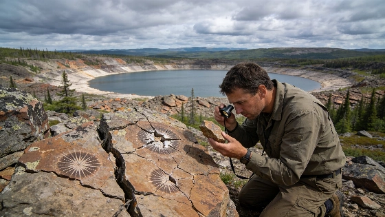
In 2025, a research team led by Western University planetary geologist Gordon Osinski visited the site, now referred to as the Uhackatik structure with the approval of the Innu Council of Ekuanitshit. The team documented several features consistent with a meteorite impact, including shatter cones-distinctive, radiating fracture patterns in rocks formed by high-pressure shock waves. They also identified impact melt rocks, which are created when the energy of an impact event melts large volumes of bedrock. The preservation of these melt rocks is notable, as such materials are typically among the first to erode away over geological timescales.
Most diagnostic evidence for impact events is microscopic, but the presence of visible shatter cones and melt rocks provides strong preliminary support for an impact origin. The structure's estimated diameter is approximately 25 kilometers (15 miles), and its age is inferred to be around 390 million years, placing it in the Devonian period. These characteristics make Uhackatik one of the largest and oldest impact candidates identified in Canada in recent decades.
Comparisons and Scientific Context
The discovery of a well-preserved ancient crater on Earth is rare, as erosion and tectonic activity often obscure or destroy such features over hundreds of millions of years. For comparison, the Hiawatha structure in Greenland, identified in 2018, is of similar scale but remains buried beneath ice, complicating direct study and leaving its impact origin debated. In contrast, the Uhackatik structure is exposed at the surface, allowing for direct geological investigation.
On the Moon, craters of comparable size and age are more common due to the lack of atmosphere and geological activity. The Tycho crater, for example, offers a glimpse of what Uhackatik may have resembled shortly after formation. On Earth, the Kamestastin (Mistastin) crater in Labrador serves as a terrestrial analog, both in size and preservation. Kamestastin has been used as a training site for Artemis II astronauts, including Jeremy Hansen and Christina Koch, to prepare for lunar geology fieldwork. The presence of anorthosite-a mineral common at the Moon's south pole-at Kamestastin further strengthens its value for comparative planetology.
Ongoing Analysis and Confirmation
While the field evidence at Uhackatik is compelling, full confirmation of its impact origin requires detailed laboratory analysis. Researchers are examining rock samples for microscopic shock features, such as planar deformation in quartz and high-temperature melt chemistry, which are definitive indicators of meteorite impacts. The findings are scheduled for presentation at the 88th Annual Meeting of the Meteoritical Society in Frankfurt, Germany, in August 2026, but have not yet undergone peer review.
Ancient impact structures like Uhackatik provide valuable data for understanding the frequency and consequences of large impacts on Earth and other rocky bodies. The preservation of diagnostic features in such old craters is uncommon, offering rare opportunities to study the long-term geological evolution of impact sites. For context, recent research on exoplanets has also relied on remote sensing and surface feature analysis, as seen in studies of atmospheric retention on rocky worlds such as LHS 1140 b.
Scientific Implications and Next Steps
If confirmed, the Uhackatik structure would join a select group of large, ancient impact craters with well-preserved geological evidence. Such sites are critical for calibrating models of planetary bombardment, surface evolution, and the role of impacts in shaping planetary environments. The ongoing analysis will clarify the structure's origin and contribute to broader efforts to map and understand Earth's impact history. The research also highlights the value of citizen science and remote sensing tools in identifying new geological features worthy of investigation.
Further fieldwork and laboratory studies are expected to refine the age estimate, characterize the impactor, and assess the extent of shock metamorphism. The results will inform both terrestrial geology and comparative studies of impact processes across the solar system.
Impact craters are identified through a combination of field observations and laboratory analysis. Key diagnostic features include shatter cones, impact melt rocks, and microscopic shock effects in minerals such as quartz. While circular structures can form through volcanic or tectonic processes, only specific shock-related features confirm an impact origin. The process of confirmation often involves petrographic microscopy, geochemical assays, and comparison with known impact sites. The rarity of well-preserved ancient craters on Earth is due to ongoing erosion, sedimentation, and plate tectonics, which gradually obscure or destroy impact evidence over time.