Archaeologists using drone-based LiDAR have mapped over 2.5 kilometers of previously undocumented pre-Columbian roads and terraces beneath rainforest near Machu Picchu, challenging assumptions about the extent of Inca landscape development
Laser scanning has revealed a network of ancient roads and terraces hidden beneath the rainforest near Machu Picchu, prompting archaeologists to rethink how the Inca used the eastern slopes of the Andes. The findings, produced by a Polish-Peruvian team in 2026, show that the region's infrastructure was larger and more complex than earlier records suggested. This has implications for how researchers understand Inca settlement, movement, and land use. The Peruvian Ministry of Culture announced the discovery on August 10, 2026, after fieldwork in July. The project also highlights the importance of international partnerships in archaeology, with involvement from institutions like the Max Planck Society and Harvard University.
Remote sensing in dense forest
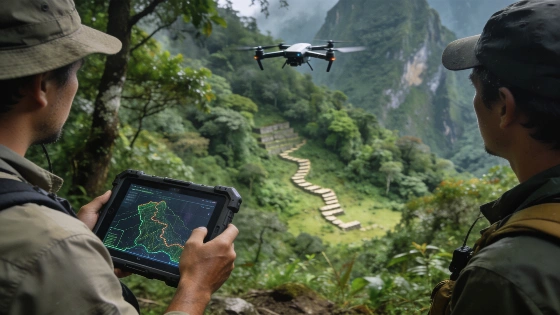
The study area sits on the slopes of Mount Yanantin, east of Machu Picchu, where thick rainforest has long hidden archaeological remains. The survey covered elevations between about 2,000 and 2,700 meters, in a region where fieldwork is slow and difficult. In some cases, it took a researcher three hours to cover just 250 meters with a machete. To get around these obstacles, the team used drones equipped with LiDAR (Light Detection and Ranging), which sends out laser pulses to measure ground elevation through dense foliage. By digitally removing the vegetation, archaeologists created detailed 3D models of the landscape, exposing narrow, zigzagging paths, terraces, platforms, and circular structures that were invisible from the ground. This method follows recent advances in archaeological remote sensing published in journals like Nature.
Some of the paths were already known to local residents, but the LiDAR data revealed a much larger network. The longest continuous section found so far runs at least 1.2 kilometers, and the total mapped length is over 2.5 kilometers. The team expects this number to grow as they continue analyzing the data, noting that only the first stage of interpretation is complete. These results show the value of combining advanced technology with local knowledge and on-the-ground checks, an approach supported by research centers such as MIT and Stanford.
Assessing Inca construction and chronology
The newly mapped roads have zigzag patterns and construction details similar to known Inca engineering, but researchers warn that not every segment is necessarily Inca. Some routes may be older and could have been reused or changed over time. To determine the age of each section, targeted excavation and further study will be needed, since surface features alone cannot provide secure dates. Officials from the Peruvian Ministry of Culture point out that while digital mapping is a powerful tool, it does not replace the need for physical excavation and careful analysis, a view also reflected in recent Science journal articles on archaeological methods.
More than 60 archaeological sites are already recorded within Machu Picchu National Park, most on the left bank of the Urubamba River. The new discoveries show that the opposite side of the river, including the Mandor region, also saw significant development. This challenges earlier models that focused on a smaller core area and suggests a wider, more connected landscape of infrastructure and activity.
Implications for Inca landscape organization
The discovery of more terraces, platforms, and circular structures along the roads points to a landscape that was managed more intensively than previously thought. These features may have supported farming, settlement, or ritual use, but their exact purposes are still unclear and will require excavation and further analysis. The research team, which includes specialists from the University of Warsaw and Peruvian heritage authorities, is now seeking permission for targeted digs and expanded LiDAR surveys. To protect the sites, the exact locations are not being made public.
Drone-based LiDAR has become a key tool in archaeological research, especially in places where thick vegetation or rough terrain make traditional surveys difficult. Similar advances have been reported elsewhere, such as in mapping underwater heritage sites in the Red Sea, as reported earlier. At Machu Picchu, the technology is revealing new features and prompting a fresh look at how the Inca shaped and connected their environment.
With elevations between 2,000 and 2,700 meters and dense rainforest, the preservation of these features is both impressive and fragile. The research highlights the need for careful management and more study before drawing broad conclusions about Inca infrastructure or society. While the evidence points to a larger and possibly older network of roads and terraces, the exact age, function, and cultural origins of each element are still open questions. The current work shows the benefits of combining remote sensing with fieldwork, but also the limits of what surface mapping alone can tell us. Going forward, the challenge will be to balance new technology with careful archaeological practice and site protection.
LiDAR (Light Detection and Ranging) is a remote sensing method that uses laser pulses to measure distances and create high-resolution elevation maps. In archaeology, LiDAR is especially useful in forested or overgrown areas where traditional surveys are blocked by vegetation. By digitally removing trees and plants from the data, researchers can see subtle features-like ancient roads, terraces, or building platforms-that would otherwise stay hidden. However, LiDAR only shows the shape of the ground; to interpret and date archaeological features, ground checks, excavation, and context are still needed to tell cultural remains from natural formations and to establish their age and use.