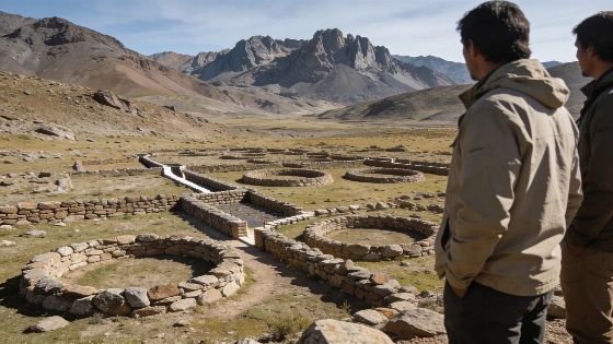
A remote survey in Mendoza province has confirmed huge circular stone structures linked by passageways at more than 3,000 meters above sea level. Their date and purpose remain unresolved
High in Mendoza province's Cordillera del Tigre, researchers have reached a complex of monumental stone circles that satellite imagery first exposed and fieldwork later confirmed. The structures sit more than 3,000 meters above sea level and include linked circular enclosures, passageways, walls, ditches and partially buried stones. Their scale is clear from above, but their builders and date are not.
The discovery is significant partly because it was made through remote sensing rather than excavation. A geometric pattern visible in satellite imagery can identify a promising archaeological target, but it cannot by itself establish chronology, cultural affiliation or function. The same distinction underlies landscape surveys conducted with satellite data by organizations such as NASA and ESA: image-based detection is a first step, not a complete archaeological interpretation.
The location offers no easy route to interpretation. Scarce water, severe terrain and little or no communications infrastructure made access difficult, and two earlier attempts were abandoned because of weather and geography. Carlos Gobbi, Adrián Radich and Gabriel Orofino eventually reached the site on 14 February 2026 after a four-day journey through the mountains.
They were following a remote-sensing clue rather than a documented excavation target. Gobbi had identified the formations in May 2025 while examining satellite images and digital maps of the region, where the geometric shapes appeared sharply different from the surrounding landscape.
The ground inspection added physical detail but did not resolve the central question. Researchers observed large circular structures connected by corridors, above-ground walls and partially buried stones incorporated into ditch-like features resembling channels. Reports describe the largest circles as measuring between 27 and 35 meters in diameter. This remains a preliminary description, pending detailed planimetric recording and further field investigation.
The numerical profile is unusually clear for a discovery still at the preliminary stage: the site lies above 3,000 meters, its largest reported circles range from 27 to 35 meters across, and the first successful approach required four days of travel. The structures were identified in May 2025 and examined on the ground on 14 February 2026. No date for construction has yet been established.
Researchers have not reported surface evidence demonstrating permanent domestic occupation. That absence does not prove that people never lived or worked there. It does, however, make a straightforward interpretation as a settled habitation less secure and leaves open the possibility of a ritual, symbolic or ceremonial function. The research team has also indicated that interpretation and protection of the site should include the views of Indigenous communities in Uspallata.
The aerial arrangement has prompted comparisons with Peru's Nazca Lines, where large-scale designs are especially legible from above. The comparison is visual rather than a demonstration of shared origin or purpose. A related case involving the interpretation of a large archaeological feature can be found in a related case, but the Mendoza complex requires its own evidence base.
Possible connections to the Inca period or to pre-Hispanic populations that occupied the region before Inca expansion remain unconfirmed. No published record of a comparable archaeological site in Mendoza is known to the researchers involved. They describe the complex as unprecedented in the region's archaeology, but that novelty does not establish a previously unknown civilization or a single cultural attribution.
Investigation is being pursued through ArqueoAndes, a binational project involving specialists from Argentina and Spain. Participants include researchers associated with the Argentine Institute of Snow Research, Glaciology and Environmental Sciences, known as IANIGLA-CONICET, and the University of Jaén in Spain. The work is proceeding with authorization from the Dirección Provincial de Patrimonio.
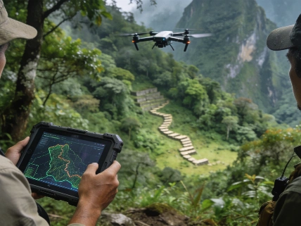
The next phase is expected to combine planimetric surveying, pedestrian inspection, geochemical sampling, geoarchaeology, drone documentation and additional remote sensing. These methods can help determine whether visible features were built during one episode or accumulated over time, identify construction materials and associated sediments, and clarify how the structures relate to one another. Comparable combinations of geophysical characterization and archaeological mapping are discussed in the Nature research overview, although no published result from that literature dates or interprets the Mendoza site.
Laboratory analysis will be particularly important because the current evidence is largely structural and spatial. Sediment samples may reveal layers associated with construction, erosion or human activity, while geochemical measurements could help distinguish transported material from local stone. Drone-based photogrammetry can produce a detailed three-dimensional record of walls, corridors and surface relief before any intervention takes place. None of these planned methods, however, has yet produced a chronology for the Cordillera del Tigre complex.
The discovery's strongest contribution is physical and geographic: it documents an extensive human-made-looking arrangement in a difficult Andean environment that had not been reported in published regional archaeology. It does not yet establish who built it, when construction occurred, whether the circles were used simultaneously or what activities took place inside them.
Remote sensing is especially valuable in terrain that is dangerous or difficult to reach, but it begins with patterns on a surface or image. Geometric forms can identify targets for investigation; they cannot by themselves provide a date, cultural affiliation or function. Field context, sediment evidence and transparent documentation are what can convert an intriguing shape into an archaeological argument.
The Cordillera del Tigre complex therefore deserves sustained study rather than a premature label. Its size and setting make it a significant discovery for Mendoza archaeology, while the missing chronology and sparse surface evidence impose firm limits. Until ArqueoAndes produces results from fieldwork, sampling and geoarchaeological analysis, the responsible conclusion is that the Andes have yielded a substantial new site whose meaning remains open-not a solved ceremonial monument or a lost civilization.
Remote sensing does not date a structure directly. It detects surface patterns that may reflect walls, ditches or other landscape modifications, after which archaeologists must verify them on the ground and test associated deposits. Sediment analysis can help identify human activity and construction sequences, but only results from the planned studies can narrow the chronology. In this case, the method has successfully found a target; it has not yet answered what the target was.