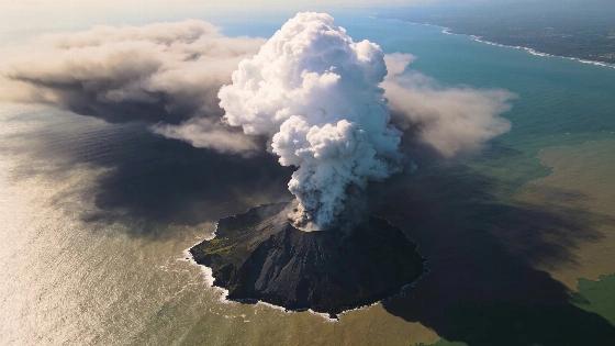
NASA and USGS's Landsat 8 satellite recorded Anak Krakatau's eruption as volcanic gas and ash reached the atmosphere, grounding flights and halting local activity while the volcano remains active
When Anak Krakatau erupted on September 4, 2026, the event was not only visible to those on the ground but also to satellites orbiting hundreds of kilometers above Earth. The eruption's impact was immediate and far-reaching, with air travel suspended, schools closed, and fishing halted across the region as volcanic ash drifted into populated areas.
Satellite Observation and Eruption Details
The Landsat 8 satellite, operated jointly by NASA and the United States Geological Survey (USGS), recorded a striking image of Anak Krakatau on September 5. The satellite's sensors detected a dense white plume of volcanic gas rising from the island, surrounded by darker clouds of ash and debris. This observation confirmed that the eruption was forceful enough to inject material high into the atmosphere, with the plume composed primarily of water vapor, carbon dioxide, and sulfur dioxide. The brown ash clouds, meanwhile, signaled the presence of fine volcanic particles capable of disrupting air traffic and daily life far beyond the immediate vicinity of the volcano.
During the 25-hour eruption, ash was carried into the airspace above Jakarta and Lampung province, prompting authorities to ground flights and issue public safety warnings. The eruption's duration and intensity were sufficient to keep Anak Krakatau in an active state throughout the following weekend, with ongoing seismic monitoring indicating the potential for further activity.
Geological Context and Historical Significance
Anak Krakatau is part of Indonesia's volatile volcanic landscape, which includes more than 500 volcanoes-127 of them currently active. The island itself emerged in 1927 from the caldera left by the catastrophic 1883 eruption of Krakatau, an event that remains one of the most destructive volcanic episodes in recorded history. The name Anak Krakatau translates to "child of Krakatau," reflecting its origin from the remnants of its infamous predecessor.
The volcano sits within the so-called "Ring of Fire," a tectonically active zone encircling the Pacific Ocean that stretches for approximately 40,000 kilometers. This region is home to over 750 volcanoes and is responsible for a significant proportion of the world's earthquakes and eruptions. While the precise boundaries of the Ring of Fire are debated among geologists, its influence on seismic and volcanic activity in Indonesia is undisputed.
Instrument Capabilities and Data Interpretation
Landsat 8 is equipped with the Operational Land Imager (OLI), which collects data in visible, near-infrared, and shortwave infrared wavelengths. This allows scientists to distinguish between volcanic gases, ash, and other atmospheric components. The satellite's ability to monitor eruptions in near real time provides critical information for hazard assessment and response, especially in densely populated regions where volcanic activity can disrupt transportation and threaten public health.
Satellite-based monitoring complements ground-based observations, offering a broader perspective on plume height, dispersion, and composition. The data collected during Anak Krakatau's eruption will be used to refine models of volcanic gas emissions and ash transport, supporting both immediate response and long-term research into volcanic processes.
Regional Impact and Ongoing Monitoring
The eruption's effects were not limited to the island itself. Ashfall in Jakarta and Lampung province led to the suspension of flights and the closure of schools, while fishing activities were halted due to safety concerns. These disruptions highlight the vulnerability of infrastructure and daily life to volcanic hazards in Indonesia's densely populated archipelagos.
As Anak Krakatau remains active, authorities continue to monitor seismic signals and satellite imagery for signs of renewed eruptions. The event underscores the importance of integrated observation networks, combining satellite data with ground-based sensors to provide timely warnings and minimize risk. For context on how satellite monitoring is transforming our understanding of dynamic Earth processes, see the earlier breakdown of recent advances in orbital observation technology.
While Anak Krakatau's latest eruption did not reach the catastrophic scale of its 19th-century ancestor, the rapid detection and response enabled by modern satellites demonstrate how far volcanic monitoring has advanced. The ability to track eruptions from space is now an essential tool for managing risk in one of the world's most geologically active regions.
Volcanic plumes are columns of gas and ash ejected during eruptions, and their detection from space relies on the unique spectral signatures of different materials. Instruments like Landsat 8's OLI can distinguish water vapor, sulfur dioxide, and ash by measuring reflected and emitted light at specific wavelengths. This capability allows scientists to estimate plume height, composition, and movement, providing critical data for aviation safety and public health. However, satellite observations are limited by cloud cover, spatial resolution, and the need for ground-based calibration, making integrated monitoring essential for accurate hazard assessment.