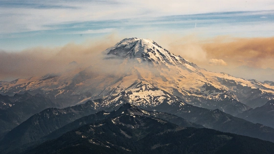
Astronauts aboard the International Space Station have recorded extensive wildfire smoke blanketing Mount Rainier and other Cascade volcanoes, revealing the scale of ongoing fires in the Pacific Northwest as seen from orbit
Recent images captured by astronauts on the International Space Station (ISS) have revealed the extent of wildfire smoke enveloping the Cascade volcanoes in the Pacific Northwest. The photographs, taken from low Earth orbit, show Mount Rainier and Mount Hood shrouded in dense plumes, highlighting the atmospheric impact of ongoing wildfires across Washington and Oregon.
Observing Wildfire Smoke from Orbit
In July and August 2026, hundreds of wildfires have burned across Canada and the northwestern United States, with the most severe activity concentrated in Washington and Oregon. According to NASA, more than 84,000 acres (approximately 34,000 hectares) were affected in these two states by August 12. The ISS crew documented the movement of smoke from central and eastern Washington toward Mount Rainier, while additional imagery captured Mount Hood, located about 160 kilometers south, under similar conditions.
These orbital observations provide a unique vantage point for assessing the spatial reach of wildfire smoke. The images show not only the volcanoes themselves but also the transport of smoke across regional atmospheric currents. In the case of Mount Hood, the thickest plumes are associated with the Grasshopper fire, which was ignited by lightning and has contributed significantly to local air quality degradation.
Fire Season Severity and Regional Impact
This year's fire season is among the most severe in the Pacific Northwest in over three decades, with widespread evacuations, road closures, and persistent air quality alerts. By August 12, more than 2.7 million acres (1.1 million hectares) had burned across the broader region, and dozens of wildfires remained uncontained as of August 14, according to reporting from CNN. The scale of the smoke plumes observed from space underscores the atmospheric consequences of these fires, which extend far beyond the immediate burn zones.
Satellite and ISS imagery have become essential for tracking the evolution of wildfire smoke and its effects on populated areas. The ability to monitor these events from orbit allows for rapid assessment of smoke dispersion, which is critical for public health advisories and emergency response. The persistent haze over the Cascade volcanoes is a visible marker of the fires' reach and intensity.
Role of Space-Based Monitoring
Space-based platforms such as the ISS and Earth-observing satellites provide data that complement ground-based firefighting and air quality monitoring. High-resolution images from orbit can reveal the movement of smoke plumes, identify new fire outbreaks, and support modeling of atmospheric transport. These observations are particularly valuable during periods of widespread fire activity, when ground access may be limited or hazardous.
Remote sensing also enables scientists to compare current fire seasons with historical records, improving understanding of trends in wildfire frequency and severity. The integration of orbital imagery with meteorological and ground-based data supports more accurate forecasting of smoke impacts and helps inform both immediate response and long-term planning.
Climate Context and Ongoing Risks
Elevated wildfire risk is expected to persist through August, according to the National Interagency Fire Center. The increasing frequency and intensity of wildfires in the region are consistent with broader trends linked to climate change, including higher temperatures and prolonged drought. While the immediate focus remains on containment and public safety, the long-term implications for air quality, ecosystem health, and regional climate are under active study.
Space-based observations are not limited to wildfires. Astronomical events such as the Perseids meteor shower, which recently peaked in August, are also monitored from orbit and ground-based sites, as described in this recent coverage of meteor activity. Together, these observations demonstrate the value of orbital platforms for both environmental monitoring and astronomical research.
Understanding the movement and impact of wildfire smoke relies on remote sensing techniques that detect atmospheric aerosols and trace gases. Instruments aboard the ISS and satellites use visible and infrared wavelengths to distinguish smoke from clouds and surface features. By analyzing the spectral signatures of smoke, scientists can estimate its composition, altitude, and transport pathways. These data are integrated with meteorological models to predict air quality and inform public health decisions, illustrating the intersection of space science and environmental monitoring.