Archaeologists have exposed a 90-meter stretch of the Alblimes Road, a Roman route dating to the 1st century CE, during excavations ahead of motorway construction on the Swabian Alb, revealing new evidence for ancient frontier infrastructure
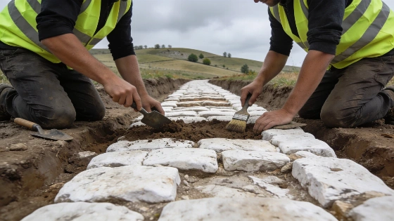
Archaeological investigations on the Swabian Alb plateau in southwestern Germany have revealed a substantial section of the Alblimes Road, one of the region's earliest Roman transport routes. The discovery was made during pre-construction excavations for the new A8 motorway ascent near Drackenstein, led by the State Office for the Preservation of Historical Monuments (LAD) in collaboration with the archaeological consortium fodilus and ArchaeoBW. The exposed segment measures approximately 90 meters and is constructed from locally quarried white Jurassic limestone, consistent with Roman engineering practices in the area.
Evidence for Roman Frontier Networks
The Alblimes Road linked the Roman settlements of Rottweil and Heidenheim an der Brenz, forming a key component of the infrastructure supporting the province of Germania Superior. Archaeological context and construction techniques suggest the road dates to the reign of Emperor Vespasian in the 1st century CE. The Swabian Alb's strategic position, a 200-kilometer-long limestone plateau, made it a focal point for Roman frontier defense, with the Alblimes system connecting a series of forts such as Urspring and Donnstetten. The road's alignment and material composition provide direct evidence for the logistical planning required to maintain military and administrative control along the empire's northern boundary.
Excavations have confirmed that the road was built using locally sourced limestone, with its surface and foundation layers preserved in situ. The segment's preservation allows for detailed study of Roman construction methods and the integration of transport routes with military installations. The road's proximity to known fort sites supports interpretations of coordinated frontier management, a pattern also observed in other Roman military landscapes, such as the expanded siege network recently documented at La Loma in northern Spain (see analysis of Roman military logistics in Spain).
Chronology, Preservation, and Research Status
Historical sources and previous archaeological work had suggested the existence of the Alblimes Road, but direct evidence remained limited until systematic excavations in the 19th and 20th centuries. The current project has provided one of the most extensive exposures of the road to date, with the 90-meter segment offering a rare opportunity to examine construction details and stratigraphic relationships. The road is attributed to the early Roman period based on typological analysis and its association with frontier installations established during the expansion of Germania Superior.
Excavations are ongoing and are expected to continue through the end of 2026, with archaeologists aiming to recover further evidence of the Roman frontier landscape before motorway construction advances. The site's preservation is variable, with some sections of the road surface and foundation intact, while others have been affected by later disturbance or erosion. The project is being conducted under heritage management protocols to balance infrastructure development with the protection of archaeological resources.
Interpreting Roman Transport and Frontier Organization
The Alblimes Road's discovery contributes to a growing body of evidence for the complexity of Roman frontier systems in central Europe. The road's construction and maintenance would have required significant labor and material investment, reflecting the importance of secure communication and supply lines for military and administrative purposes. Its alignment with forts and settlements indicates a deliberate strategy to integrate transport infrastructure with defensive and logistical needs.
While the road's primary function was likely military, its existence also facilitated trade and movement of goods, people, and information across the frontier zone. The archaeological record does not permit precise reconstruction of traffic volume or the identities of all users, but the road's scale and durability suggest sustained use over at least a century. The Alblimes system is now recognized as a cultural monument of national significance, with ongoing research expected to clarify its development and role within the broader Roman frontier landscape.
Roman road construction in frontier regions relied on standardized engineering techniques, including the use of local materials, layered foundations, and careful alignment with topography and existing settlements. The preservation of the Alblimes Road segment allows for comparative analysis with other Roman roads and supports broader interpretations of imperial infrastructure and regional integration during the early centuries CE.
Roman roads are often identified through a combination of historical records, surface traces, and archaeological excavation. Stratigraphic analysis is essential for distinguishing original construction layers from later modifications or disturbances. In the case of the Alblimes Road, the survival of foundation and surface materials in situ provides a secure basis for dating and interpretation. However, preservation is uneven, and later land use, erosion, and construction can obscure or destroy sections of ancient routes. Archaeologists rely on a combination of field survey, excavation, and comparative typology to reconstruct the original extent and function of Roman transport networks.