Archaeologists excavating at Saint-Georges-de-Didonne have identified extensive defensive earthworks and settlement traces from a medieval stronghold, offering new evidence for the site's strategic role and long-term occupation in southwestern France
Archaeological investigations at Saint-Georges-de-Didonne, Charente-Maritime, have revealed substantial remains of a medieval fortified complex once overlooking the Gironde estuary. The work, led by France's National Institute for Preventive Archaeological Research (Inrap), was initiated in advance of planned social housing construction and has focused on a 6,475-square-meter area encompassing both the former stronghold and its associated settlement.
Defensive Architecture and Strategic Setting
The site occupies a limestone slope above the Riveau valley, near the Atlantic coast where the Gironde estuary meets the ocean. Although the Château de Didonne itself has not survived, historical records confirm its existence from at least the 11th century CE, with the stronghold playing a documented role during the Hundred Years' War. The location allowed medieval lords to monitor maritime access and control shipping routes along the estuary.
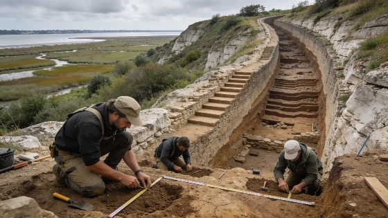
Excavations have identified two concentric defensive ditches, or moats, encircling the former castle. The inner moat measures nearly 15 meters wide and at least 6.5 meters deep relative to the presumed base of the curtain wall. Along its inner edge, archaeologists documented a reinforced rock embankment at least 10 meters wide, supported by stepped rockfill reaching five meters in height. The embankment's core consists of organic or limestone deposits, likely derived from the original moat excavation, and was later covered with marl and vegetation. The outer moat, separated from the inner ditch by a 10-meter strip of land, is also about 15 meters wide but shallower at 2.7 meters deep. Both ditches drain toward the Riveau valley, and their scale suggests significant investment in fortification by the medieval elite.
Settlement Evidence and Chronology
Beyond the defensive works, the excavation has uncovered traces of a medieval village that developed around the stronghold. Archaeologists have identified underground silos for crop storage, postholes indicating timber structures, smaller ditches organizing the settlement, and at least two wells. In some areas, the construction of the inner moat and embankment cut through earlier domestic remains, indicating that habitation predated the most monumental phases of fortification. Evidence for occupation on the Didonne hill extends back to the Carolingian period, several centuries before the castle's medieval prominence.
Across the site, the visible landscape today is marked by the place name Le Châta and a network of ditches, the last surface reminders of a once-important center of local power. The current research builds on an earlier archaeological assessment from 2012 and aims to clarify the sequence of construction and occupation. One key question is whether the two moats were built as part of a single project or represent successive phases of defensive strengthening.
Material Evidence and Research Limitations
The physical evidence at Saint-Georges-de-Didonne consists primarily of earthworks and settlement features, as the castle's above-ground structures have not survived. The dating of the defensive system relies on stratigraphic relationships and historical documentation, with the main embankment and inner moat attributed to no later than the 12th century CE. The absence of standing architecture limits the ability to reconstruct the full layout or appearance of the stronghold, but the scale and engineering of the ditches provide rare insight into the resources and priorities of the medieval seigneurial class in this region.
While the Didonne site is notable for its defensive complexity, it is part of a broader pattern of medieval fortifications and settlements across Europe. Comparable research at other sites, such as the recent excavation of an Etruscan ritual well with bronze offerings and human remains near Marzabotto, Italy, has also highlighted the value of integrating settlement, defensive, and ritual evidence to reconstruct past landscapes and social organization. For more on the interplay between ritual and settlement archaeology, see this analysis of Etruscan urban foundations at Kainua near Marzabotto.
The ongoing work at Saint-Georges-de-Didonne offers an opportunity to refine our understanding of medieval settlement dynamics, fortification strategies, and the long-term occupation of the Gironde estuary's strategic approaches. As excavation continues, further analysis of the site's stratigraphy and material culture may clarify the relationship between the stronghold, its associated village, and earlier phases of occupation.
Understanding the archaeological context of defensive earthworks like those at Saint-Georges-de-Didonne depends on careful stratigraphic analysis. Stratigraphy involves recording the sequence of soil layers, features, and deposits to establish the relative chronology of construction, use, and abandonment. In the absence of direct dating methods such as radiocarbon analysis for stone or earth structures, archaeologists rely on the relationships between features, associated artifacts, and historical records to build a timeline. This approach allows researchers to distinguish between single-phase and multi-phase construction, identify episodes of remodeling or reuse, and assess the impact of later disturbance. Stratigraphic evidence is essential for interpreting the development and function of complex sites where above-ground architecture has not survived.