Excavations near Puck have exposed more than 300 features, including two circular trenches around a possible 15th-century windmill and a Lutheran cemetery with about 150 graves.
Two broad circular trenches cut into Windmill Hill near Puck may be the remains of a fortified medieval windmill position built during the conflicts that reached the town in the 15th century. The interpretation is not yet confirmed, but the physical evidence gives archaeologists a rare opportunity to test whether field defenses from the Thirteen Years' War survive beneath a later cemetery.
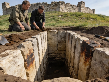
Archaeologists from the University of Warsaw excavated more than 5,000 square meters about 300 meters west of the medieval town. They recorded more than 300 archaeological features, showing that the hill was used repeatedly over more than two millennia. The two most significant features are circular trenches measuring approximately 30 and 50 meters in diameter. The excavation therefore documents a substantial archaeological landscape rather than an isolated medieval structure.
Each trench was about 1.5 meters deep and between 1.5 and 2.5 meters wide. Sand and clay largely filled them. Their form and position around the hill's central area are consistent with defensive moats, possibly combined with a low rampart, but excavation has not yet demonstrated that they were military works. The researchers' preferred interpretation remains provisional: the rings may have enclosed a central installation, but their function must still be tested through stratigraphy, dating, and comparison with other medieval earthworks.
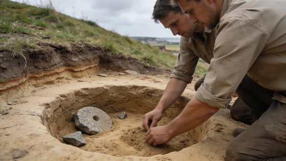
Inside the enclosed space, researchers found the basement of an unidentified building and substantial fragments of grooved granite millstones. A smaller neighboring structure included a wooden cellar. Around a dozen stone cannonballs were also recovered, adding a military dimension to the site without proving that the trenches and projectiles belonged to one event. The association is archaeologically suggestive, yet objects found within the same enclosure can represent different phases of occupation.
Historical evidence provides the proposed setting. A 1634 map calls the area Muhlenberg or Mill Hill, while records refer to windmills associated with Puck during the 15th century. Archaeologists think a Teutonic windmill may have stood at the center of the rings, although no surviving structural remains of the mill itself have been identified. The central feature is inferred primarily from historical references, the location of the millstone fragments, and the arrangement of the earthworks.
The millstone fragments support the presence of milling activity, and the manufacturing technique belongs to the late Middle Ages. They do not by themselves establish the building's exact date or show that the windmill was fortified. The trenches could have been constructed with the mill or added later when the hill became strategically important. A secure chronological sequence would require demonstrable stratigraphic relationships and, if suitable material survives, laboratory dating.
Puck changed hands during the Thirteen Years' War between 1454 and 1466. Teutonic forces captured the town in 1460, while forces from Gdańsk besieged the Teutonic position there in 1464. A raised position beside the town could have mattered during either episode, but the excavation has not linked the trenches to a specific siege. Historical reconstruction narrows the possible context without identifying the event that created the earthworks.
The evidence therefore supports a measured claim: Windmill Hill may preserve an unusual defensive installation connected to a period of warfare. It does not yet establish the exact builder, date of construction, or military episode. That distinction matters in a site where later activity has overlaid the suspected fortifications. As with field archaeology reported in the excavation coverage, the strongest conclusions are those that separate observed features from historical interpretation.
The hill's history extends well beyond the medieval period. The earliest structures have been associated with Lusatian culture settlement probably during the first half of the first millennium BCE. Archaeologists also identified about a dozen pits from the early Middle Ages, showing that the location was used before the suspected windmill.
During the 16th century, a substantial part of the excavated area was transferred to Puck's Protestant community. A Lutheran cemetery was later established there, producing approximately 150 graves. Human remains were generally poorly preserved, limiting what future osteological study may be able to say about the people buried on the hill. Poor preservation can reduce the number of measurable skeletal traits and restrict analyses of age, sex, disease, and population structure, so any demographic conclusions would need to be presented with explicit uncertainty.
Four coins dating from the second half of the 15th century and the 16th century were recovered with the burials. Researchers also found a one-piece clay tobacco pipe from the 17th century. The coins may relate to the practice sometimes called Charon's obol, in which a coin was placed with the dead, while the pipe may have been a personal possession. Neither interpretation is certain without more detailed burial and contextual analysis.
The excavation's layered evidence resembles the interpretive challenge described in an earlier excavation report: individual objects become historically useful only when their location and associations are kept separate from later interpretation.
Further work is expected to refine the dating of the human remains and assess the biological condition of the local population in more recent centuries. It may also clarify whether the circular cuts were deliberately engineered defenses or features with another function. The poor preservation of the burials means that any conclusions about health or demography will depend on which skeletal elements survived and whether the recovered graves represent the wider community.
No radiocarbon program or other laboratory dating method is reported for the trenches in the available account. Their chronology currently rests on the combination of historical records, site relationships, construction form, associated materials, and the broader sequence of activity. That is enough to make the military interpretation plausible but not enough to turn it into a confirmed battlefield identification. The excavation reports do not provide sample sizes for trench dating, statistical significance tests, confidence intervals, or results from a named analytical laboratory, so such measurements should not be inferred.
Future investigation could combine additional targeted excavation with micromorphology, sediment analysis, artifact typology, and dating of securely associated organic material if preservation permits. These methods are complementary: soil profiles can help distinguish deliberately cut ditches from natural depressions, while stratigraphy can establish sequence. None, however, automatically identifies the historical event responsible for a feature. The University of Warsaw's field evidence must therefore remain the primary basis for claims until laboratory and contextual results are published.
The strongest result is not proof of a fortified windmill but the discovery of a complex archaeological landscape in which medieval industry, possible military engineering, early settlement, and Protestant burial overlap. Windmill Hill deserves attention precisely because the material evidence narrows the possibilities without erasing uncertainty. The proposed fortifications are a credible lead for investigating Puck's wartime landscape, not a settled conclusion about it.
Archaeological dating often combines several kinds of evidence rather than relying on one decisive measurement. Historical maps and records can establish that a place or activity was known by a particular time, while artifacts and construction techniques provide broader chronological clues. Stratigraphic relationships can show which features came earlier or later, but they do not automatically identify the event that created them. At Windmill Hill, the rings therefore remain an interpretation grounded in context and form; confirming a connection to the Thirteen Years' War will require tighter dating and clearer evidence of how the trenches were used. This cautious separation of observation and inference is consistent with the evidentiary standards emphasized in leading archaeological work published across journals such as Nature.