Aerial archaeological surveys during an extended Welsh heatwave have revealed prehistoric barrows, Iron Age enclosures, Roman buildings, and First World War trenches as cropmarks and parchmarks, offering new insights into the region's archaeological landscape
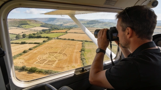
Unusually hot and dry conditions across Wales in the summer of 2026 have exposed a range of previously hidden archaeological features, as aerial surveys documented cropmarks and parchmarks revealing the outlines of ancient monuments and settlements. The Royal Commission on the Ancient and Historical Monuments of Wales (RCAHMW) conducted systematic flights over affected regions, capturing high-resolution images before the return of wetter weather obscured these ephemeral traces.
Revealing the Buried Landscape
The emergence of cropmarks-variations in plant growth caused by underlying archaeological remains-has long been a tool for identifying buried sites. This year's drought, which intensified from April through July, created optimal conditions for such discoveries. While some areas in western and southern Wales remained green until late June, a series of heatwaves rapidly desiccated the landscape, making previously invisible features stand out in aerial photographs.
Among the most prominent discoveries were a Neolithic long barrow near Welshpool, estimated to be around 5,000 years old, and a large Iron Age concentric enclosure near Lampeter, measuring approximately 170 meters across. The surveys also documented Roman-period structures within the fort at Caerhun (Canovium) in Conwy, a previously unrecorded Iron Age or Romano-British double-ditched farmstead near Llandysul in Ceredigion, and First World War practice trenches beneath a golf course at Deganwy.
Methods and Documentation
Archaeologists from the Royal Commission worked with pilots from FlyWales and Caernarfon Airport to conduct flights across the country, using both direct observation and digital image processing to enhance faint cropmarks. In some cases, features were immediately visible from the air, while others required digital rebalancing of color bands to clarify subtle differences in vegetation. The resulting images are being archived in the National Monuments Record of Wales, ensuring long-term access for researchers and the public.
Many of the sites identified during the 2026 heatwave had not been visible in such detail for two or three decades, while others represent entirely new additions to the archaeological record. The information is being shared with Cadw and regional archaeological teams to inform heritage management and protection strategies. In addition to archaeological features, the surveys also documented areas affected by recent wildfires, providing a record of environmental impact alongside cultural evidence.
Interpreting the Evidence
The visibility of buried sites through cropmarks depends on a combination of soil moisture, plant type, and the depth and composition of archaeological remains. Drought conditions can make subtle differences in soil and vegetation more pronounced, but these windows of visibility are brief and unpredictable. While aerial survey is a powerful tool for landscape archaeology, it is limited by weather, ground cover, and the need for subsequent ground verification.
Numerical data from the 2026 campaign include the documentation of at least five major new or rarely recorded sites, with the Neolithic long barrow near Welshpool displaying its clearest cropmarks in over 30 years. The Iron Age enclosure near Lampeter, at 170 meters in diameter, is among the largest of its type recorded in Wales. The surveys also contributed to the mapping of First World War practice trenches, a feature rarely preserved in the Welsh archaeological record.
Comparative Context and Ongoing Research
These findings add to a growing body of evidence that extreme weather events can play a significant role in archaeological discovery. Similar patterns have been observed elsewhere in the UK and Europe, where droughts have revealed ancient field systems, settlements, and burial monuments. For example, research on Iron Age and Roman-period cemeteries in England has also benefited from remote sensing and aerial survey, as seen in the analysis of pre-conquest burial grounds containing imported Roman artifacts (see related research on early Roman connections in Iron Age England).
As climate variability increases the frequency of droughts, archaeologists are adapting their survey strategies to take advantage of these short-lived opportunities. However, the reliance on weather-dependent methods highlights the importance of rapid documentation and the need for ground-based investigation to confirm and interpret aerial observations.
Cropmarks are a form of archaeological remote sensing that relies on differences in plant growth caused by buried features such as walls, ditches, or pits. When soil moisture is limited, plants above stone or compacted surfaces may appear stunted or discolored, while those above filled ditches may grow more vigorously. These patterns are best observed from the air and can reveal the outlines of structures invisible at ground level. However, cropmarks provide only indirect evidence of buried remains, and their interpretation requires careful correlation with ground survey, excavation, and other forms of archaeological analysis.