ESA's Mars Express orbiter has produced a new high-resolution 3D visualization of Schiaparelli Crater and the Southern Highlands, offering fresh insight into ancient Martian water activity and surface evolution
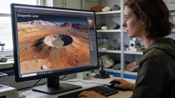
The European Space Agency's Mars Express orbiter has delivered a new high-resolution visualization of Schiaparelli Crater and the surrounding Southern Highlands, using data collected during a recent low-altitude pass. The resulting 3D renderings provide an unprecedented look at one of Mars' largest impact features, a region shaped by ancient water flows and subsequent geological processes.
Imaging Mars with High Resolution
Mars Express, launched in 2003, is equipped with the High Resolution Stereo Camera (HRSC), an instrument designed to capture the Martian surface from multiple perspectives. By recording five simultaneous viewing angles across four color channels, the HRSC enables the reconstruction of detailed three-dimensional maps. During a recent elliptical orbit, the spacecraft passed over the Southern Highlands and Schiaparelli Crater, capturing data that reveal both the scale and complexity of the terrain.
Schiaparelli Crater, located in the heavily cratered southern hemisphere, measures over 460 kilometers in diameter. Despite its size, the crater is relatively shallow, having been gradually filled by sediment from wind, ancient water flows, volcanic activity, and impact debris over billions of years. The new visualization highlights these infill processes, showing subtle variations in depth and surface texture that are not apparent in conventional images.
Ancient Water and Martian Geology
The Southern Highlands, including Schiaparelli Crater, preserve evidence of a time when Mars was warmer and wetter. Geological features such as channels and valley networks suggest that liquid water once shaped the landscape around 3.7 billion years ago. The HRSC's 3D mapping capability allows researchers to trace these features in detail, supporting models of early Martian climate and hydrology.
Schiaparelli Crater is also notable for its cultural and scientific associations. It is the fictional site where Mark Watney is stranded in Andy Weir's "The Martian," and shares its name with ESA's Schiaparelli lander, which crashed on Mars in 2016 but was not targeted for the crater itself. Both are named after Giovanni Schiaparelli, the Italian astronomer whose 19th-century observations of Martian "canali" fueled early speculation about water and life on Mars.
Data Processing and Scientific Value
The HRSC's ability to collect wide swaths of 3D data-spanning hundreds to thousands of kilometers-enables the assembly of regional maps that contribute to a global model of Mars. These datasets are stitched together to reveal the relationships between impact structures, sedimentary deposits, and volcanic features. The new Schiaparelli visualization demonstrates how modern orbital imaging can resolve subtle geological details, informing both planetary science and mission planning.
While the HRSC provides high spatial and spectral resolution, the interpretation of surface features remains subject to uncertainties in sediment composition, erosion rates, and the timing of geological events. Ongoing analysis aims to refine models of Martian surface evolution and to distinguish between processes driven by water, wind, and volcanism.
Historical and Mission Context
Giovanni Schiaparelli's 1877 map of Martian "canali"-later mistranslated as "canals"-sparked widespread interest in the possibility of intelligent life on Mars. Although subsequent observations have ruled out artificial structures, the search for evidence of past water and habitability continues to drive Mars exploration. The Mars Express mission, now in extended operations, remains a key contributor to this effort, complementing other international missions and research initiatives.
Interest in Martian surface exploration extends beyond imaging. For example, recent efforts to develop robotic systems for planetary cave exploration, such as those described in coverage of NASA-backed spherical aerobots for Titan, reflect the growing importance of advanced remote sensing and mobility technologies for planetary science.
As Mars Express continues to return data, the integration of high-resolution topography, mineralogy, and climate modeling will further clarify the planet's geological history and its potential for past habitability.
To interpret Martian surface features from orbit, scientists rely on stereo imaging, a technique that combines multiple angled views to reconstruct three-dimensional shapes. The HRSC on Mars Express captures five perspectives in a single pass, allowing for precise elevation mapping and the creation of digital terrain models. These models are essential for understanding the processes that have shaped Mars, from impact cratering to sediment transport, and for planning future lander and rover missions that require detailed knowledge of surface hazards and scientific targets.