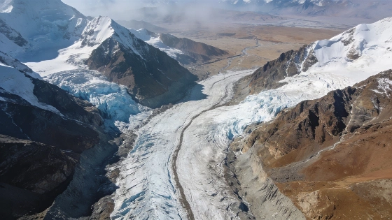
A NASA astronaut aboard the International Space Station captured detailed images of glaciers moving across the Himalayas, providing a rare perspective on the scale and dynamics of these ice flows as they descend toward the Tibetan Plateau
High-resolution images taken from the International Space Station (ISS) have revealed the movement of glaciers along the northern slopes of the Himalayas, offering a vantage point inaccessible from the ground. In May 2026, NASA astronaut Jessica Meir used onboard optical cameras to document these vast rivers of ice as they traverse the mountainous border between Nepal and China, descending toward the Tibetan Plateau.
The Himalayas, stretching approximately 2,400 kilometers across Nepal, India, China, Bhutan, and Pakistan, contain more than 110 peaks exceeding 7,300 meters in elevation, including Mount Everest. The region's glaciers are among the largest outside the polar areas, and their movement is a key indicator of both geological processes and climate-driven change. From the ISS, orbiting at an altitude of about 417 kilometers, the scale and interconnectedness of these glacial systems become apparent in a single frame-something not possible with ground-based or even aerial surveys.
Imaging from Orbit
The ISS provides a unique platform for observing Earth's surface at high spatial resolution and broad coverage. The images captured by Meir show glaciers as they flow down steep mountain slopes, carving paths through rock and sediment. These observations are not only visually striking but also scientifically valuable, as they allow researchers to monitor changes in glacier extent, flow rate, and surface features over time.
While helicopter or drone surveys can document individual glaciers or localized regions, orbital imaging enables scientists to analyze entire glacial networks and their relationship to the surrounding landscape. This perspective is essential for understanding how glaciers interact with regional topography and climate, and for detecting changes that may signal shifts in water resources or increased risk of glacial hazards downstream.
Scientific Context and Limitations
Glaciers in the Himalayas play a critical role in supplying freshwater to millions of people across Asia. Their seasonal melt contributes to major river systems, including the Ganges, Brahmaputra, and Yangtze. However, many Himalayan glaciers have been observed to retreat in recent decades, a trend linked to rising global temperatures. Space-based imaging provides a consistent, repeatable method for tracking these changes, supplementing ground-based measurements and historical records.
It is important to note that while orbital images can reveal surface features and movement, they do not directly measure ice thickness, subglacial processes, or the precise rate of mass loss. Additional data from radar, lidar, and in situ fieldwork are required to build a complete picture of glacier health and dynamics. The images from the ISS represent a valuable component of a broader observational toolkit, but they are not a substitute for comprehensive glaciological studies.
Numerical Perspective
The Himalayas span roughly 2,400 kilometers in length and include over 110 peaks above 7,300 meters. The ISS orbits at an altitude of 417 kilometers, allowing it to capture wide-area images that encompass multiple glaciers and mountain ranges in a single pass. These images can be used to estimate glacier area, monitor changes in surface morphology, and compare seasonal or annual variations in ice coverage.
Researchers use such data to calibrate models of glacier flow and to assess the impact of climate variability on regional water supplies. However, uncertainties remain regarding the rate of ice loss and the long-term stability of Himalayan glaciers, as direct measurements of ice thickness and subglacial hydrology are limited by the region's challenging terrain and political boundaries.
Remote sensing from space has become an essential tool for monitoring Earth's cryosphere. Optical imaging, such as that performed from the ISS, captures reflected sunlight from glacier surfaces, revealing patterns of flow, crevassing, and surface melt. These images are often combined with radar and lidar data, which can penetrate cloud cover and provide information on surface elevation and ice thickness. By comparing images taken at different times, scientists can track changes in glacier extent and movement, helping to quantify the effects of climate change on some of the planet's most important freshwater reserves.