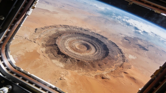
A new photograph from the International Space Station captures the Richat Structure, a 40-kilometer-wide geologic formation in Mauritania, revealing its striking concentric rings as seen from orbit
From hundreds of kilometers above Earth, astronauts aboard the International Space Station (ISS) have once again documented the Richat Structure, a vast circular geologic formation in Mauritania often called the "Eye of Africa." This feature, with its distinctive concentric rings, has been a recurring subject for orbital photography since the early days of human spaceflight.
Imaging the Eye of Africa
The Richat Structure spans approximately 40 kilometers in diameter and is composed of a series of uplifted, erosion-resistant rock layers. Its nearly perfect circular shape and prominent ridges make it a recognizable landmark from space, despite being less apparent at ground level. The latest high-resolution image was captured by NASA astronaut Jessica Meir during her tenure on the ISS as part of Expedition 75, using handheld digital cameras designed for Earth observation.
This formation first drew the attention of astronauts in 1965, when Ed White and James McDivitt photographed it during the Gemini IV mission. Since then, the Richat Structure has become a familiar target for orbital imaging, with each new photograph offering a different perspective depending on lighting, atmospheric conditions, and camera technology.
Geological Origins and Structure
Despite its striking appearance, the Richat Structure is not the result of an impact event or volcanic activity. Geological studies indicate that it formed through a combination of uplift and erosion, exposing alternating layers of sedimentary and igneous rock. The concentric rings are the result of differential erosion, where harder rock layers resist weathering more effectively than softer strata.
Estimates place the structure's diameter at about 40 kilometers (25 miles), making it one of the largest and most visually distinctive features in the Sahara. Its age and precise formation process remain subjects of ongoing research, with current models favoring a combination of geological uplift and subsequent erosion over millions of years.
Observation from Orbit
The ISS provides a unique vantage point for observing large-scale geological features. Astronauts use a suite of digital cameras and lenses to capture images of Earth's surface, contributing to both scientific research and public engagement. The Richat Structure's size and symmetry make it especially visible from orbit, and its appearance can change dramatically depending on the angle of sunlight and atmospheric clarity.
Images like those taken by Jessica Meir are archived and analyzed to support studies in geology, geomorphology, and planetary science. The ability to repeatedly image the same feature under varying conditions allows researchers to monitor changes over time and refine models of surface processes. For context, the tradition of astronaut photography of Earth's surface dates back to the Gemini program, as seen in the documentation of early spacecraft achievements such as the first controlled glide landing of NASA's M2-F1 lifting body in 1963.
Scientific Significance and Limits
While the Richat Structure is visually compelling, its scientific value lies in the insights it provides into the processes of uplift, erosion, and sedimentary rock formation. The feature serves as a natural laboratory for studying the interplay between tectonic forces and surface weathering in arid environments. However, the lack of direct sampling from the structure's deepest layers limits the precision of current geological models.
Ongoing analysis of orbital imagery, combined with field studies, continues to refine understanding of the Richat Structure's origin and evolution. The feature's accessibility to space-based observation ensures it will remain a subject of interest for both scientists and the public as imaging technology advances.
The process of imaging Earth from orbit relies on a combination of digital sensors, optical lenses, and precise timing to capture surface features under optimal conditions. Astronauts aboard the ISS select targets based on scientific priorities and visual interest, using handheld or mounted cameras to document phenomena ranging from weather systems to geological formations. The resulting images are calibrated and archived, providing a valuable dataset for researchers studying Earth's dynamic surface. The clarity and perspective offered by orbital photography are especially important for features like the Richat Structure, whose full extent is only apparent from space.