NASA and ISRO's NISAR satellite has assembled a time-lapse of lava spreading across Kamchatka's Krasheninnikov volcano, revealing how radar can track a remote hazard through repeated observations while ground reports confirm that the eruption remains active.
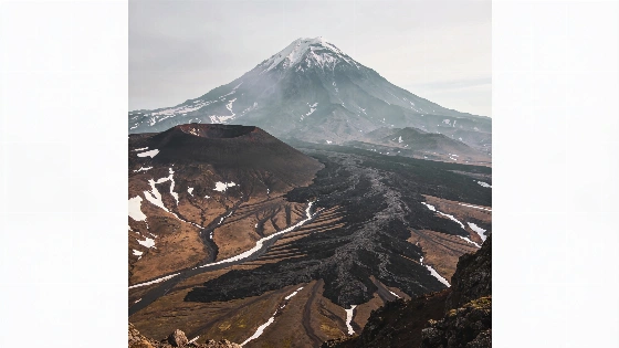
Lava has been spreading across Russia's Kamchatka Peninsula in a pattern now recorded from orbit. A sequence of radar observations from the NASA-ISRO Synthetic Aperture Radar (NISAR) shows molten rock moving east from Krasheninnikov's northern crater before widening into a fan across the volcanic landscape.
As of September 24, 2026, the eruption is continuing. Regional emergency officials describe it as an effusive-explosive eruption with an active lava flow, while a new lava block continues to grow in the northern part of the lava dome. Reports from September 19-23 also describe strong steam-and-gas activity and lava moving down the eastern slopes. The regional emergency bulletin keeps the volcano under a yellow seismic-activity code and warns that ash emissions could reach about 6 kilometers above sea level.
The earthquake is therefore part of the eruption's context rather than a confirmed cause. An 8.8-magnitude earthquake struck in the nearby ocean on July 30, 2025, and the eruption began a few days later, after Krasheninnikov had apparently been quiet since about 1550. The available observations establish the timing of the two events, while the explanation that the earthquake triggered the eruption remains an inference.
Kamchatka contains dozens of frequently erupting volcanoes and many are monitored with instruments on the ground. Krasheninnikov is a more difficult target because of its remote setting and its long period of inactivity. NISAR's observations provide a record of how the new lava field altered the surface even when direct access is limited.
Independent analyses of KVERT satellite data found that between September 10 and 15, 2026, lava continued to flow onto the eastern slope of the northern cone, while a large thermal anomaly appeared on satellite images on most days. These observations complement NISAR's radar record: thermal sensing indicates unusually hot material, whereas radar primarily documents changes in surface structure and radar reflectivity.
Radar observations are especially valuable because the eruption is not only remote but also hazardous. Emergency services do not recommend approaching the volcano, and the area remains subject to access restrictions. Officials have also warned that ash emissions could occur at higher levels, potentially reaching 12 kilometers above sea level, creating an aviation hazard even when the lava itself remains confined to the slopes.
For regional context, Krasheninnikov is being monitored alongside other active or potentially hazardous Kamchatka volcanoes, including Shiveluch, Klyuchevskoy, Bezymianny, and Mutnovsky. That concentration of volcanic activity makes repeated, wide-area satellite observations useful for comparing hazards across locations that cannot all be visited safely or frequently.
NISAR observes Earth with synthetic aperture radar rather than visible-light cameras. Its instruments send microwave pulses toward the ground and measure the returning signals. Processing combines observations gathered as the spacecraft moves along its orbit, producing a sharper representation of the surface than any single radar return could provide.
In the Krasheninnikov sequence, the lava field appears brighter than the surrounding terrain because it reflects the radar signal differently from nearby snow or bare ground. The brightness is therefore a property of the radar measurement and not a literal view of glowing red lava. The animation also shows a separate flow extending northwest that likely formed before the first NISAR image.
Each pixel in the images represents roughly a 10-by-10-meter area on the ground. That scale is about half the size of a tennis court and is fine enough to show the flow filling a smaller inner caldera, spilling into a wider crater, and then spreading outward.
The repeated coverage is as important as the individual image. NISAR first captured Krasheninnikov on December 25, 2025, from an altitude of 747 kilometers while completing post-launch checks and becoming operational. Since then, it has returned to the same location twice every 12 days, observing once on a south-to-north pass and once on a north-to-south pass. The sequence contains 17 frames collected through mid-August 2026.
The time-lapse directly documents changing surface conditions. It does not by itself measure the lava's temperature, chemical composition, eruption volume, or underground plumbing. Those questions require other observations and analyses that are not described in the available data.
Matthew Pritchard, a Cornell University geophysicist and member of the NISAR science team, analyzed the observations used for the animation. His assessment emphasizes the value of consistent repeat measurements from two viewing directions. For hazard monitoring, a reliable time series can show where a flow has advanced and how a landscape is changing between observations.
NISAR's L-band radar also allows the mission to image land beneath tree canopies in places where shorter-wavelength observations may be more affected by vegetation. The spacecraft carries both L-band and S-band radar instruments, whose different wavelengths provide complementary information about Earth's surface and vegetation.
The mission's coverage is broad enough to observe virtually all of the planet's roughly 1,300 active volcanoes above sea level. That does not mean every eruption will be equally visible or that radar observations replace ground instruments. Weather, surface conditions, viewing geometry, and the timing of satellite passes still shape what the data can reveal.
For volcano research, the technical change is substantial. More than two decades ago, when Pritchard was conducting doctoral research on Kamchatka volcanoes, radar data were less frequent, lower in resolution, and harder to prepare for analysis. NISAR now produces observations at several-meter scale and makes its L-band data available through the Alaska Satellite Facility Distributed Active Archive Center in Fairbanks.
The mission is also notable for combining two radar systems on one free-flying spacecraft. Its L-band radar and antenna reflector were supplied by NASA's Jet Propulsion Laboratory, while ISRO supplied the spacecraft bus and S-band radar. The satellite's drum-shaped reflector measures 12 meters across, making it the largest radar antenna reflector NASA has sent into space.
That architecture turns an isolated eruption into a measurable sequence rather than a single snapshot. It gives researchers a way to compare surface change across repeated passes and could support hazard assessment where direct monitoring is difficult. The evidence is strongest at that level: NISAR has mapped the evolving lava field with repeat radar observations, not predicted the eruption or independently established that the earthquake caused it.
Radar interferometry and synthetic aperture processing can make a rough landscape legible at scales far smaller than the spacecraft's altitude might suggest. The technique relies on the returning microwave signal and the satellite's precisely known motion rather than ordinary optical detail. In this case, the result is a time-resolved map of surface change, and that is exactly why NISAR's record matters: it converts a remote eruption into evidence that can be measured over time, while leaving the deeper volcanic cause to other observations.