NASA's Curiosity rover has imaged Martian rocks shaped by a powerful ancient sandstorm, offering new insight into the Red Planet's dynamic past and the processes that once shaped its surface
NASA's Curiosity rover has captured new images on Mars that researchers interpret as evidence of a powerful ancient sandstorm, providing a rare glimpse into the planet's dynamic geological history. The findings, published in the journal Geology in 2026, highlight how wind-driven processes once shaped the Martian landscape in ways that differ markedly from the planet's current, more static surface conditions.
Imaging the Aftermath
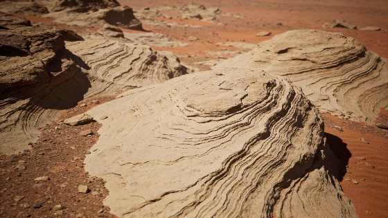
The Curiosity rover, operating in Gale Crater since 2012, recorded a series of high-resolution images in 2024 at a site informally named "Jawbone Canyon." In these images, scientists identified rock formations with distinct ripple-like textures. These features are interpreted as the lithified remnants of sand dunes sculpted by intense winds during a period when Mars still possessed a thicker atmosphere.
Analysis of the images suggests that the sandstorm responsible for these structures was unusually energetic, with wind speeds sufficient to move large volumes of sediment. Over time, these rippled sand deposits were buried and cemented into rock, preserving a record of ancient Martian weather patterns. The visible ripples in the rock provide direct evidence of the planet's once-active surface processes.
Geological Context and Methods
The study relied on Curiosity's Mast Camera (Mastcam), which captures color images and stereo pairs, allowing researchers to reconstruct the three-dimensional structure of the surface. By comparing the observed ripple patterns to terrestrial analogs and to models of sediment transport, the team inferred the likely wind strength and direction during the event. The preservation of such features indicates that Mars experienced periods of significant atmospheric activity, supporting the view that its climate has changed dramatically over billions of years.
While the image was taken in 2024, the detailed analysis and interpretation were only recently published, underscoring the importance of long-term data review in planetary science. The study adds to a growing body of evidence that Mars once had rivers, lakes, and a more substantial atmosphere, all of which contributed to shaping its surface.
Historical Perspective and Ongoing Exploration
This discovery comes fifty years after NASA's Viking 1 lander became the first spacecraft to successfully operate on the Martian surface, marking a turning point in planetary exploration. Since then, missions like Curiosity and Perseverance have expanded our understanding of Mars' geological and climatic evolution. The ability to identify and interpret ancient weather events from surface imagery demonstrates the increasing sophistication of rover-based science.
Comparisons with other planetary observations, such as the study of glacier movement on Earth from space, highlight the value of remote sensing in reconstructing past environmental conditions. For example, a recent analysis of Himalayan glaciers using space-based imagery illustrates how similar techniques are applied across planetary bodies to understand surface processes and climate history.
Limits and Uncertainties
While the evidence for an ancient sandstorm is strong, uncertainties remain regarding the precise timing and duration of the event. The interpretation relies on analogies with terrestrial sedimentary structures and on models of Martian atmospheric dynamics, both of which have inherent limitations. Alternative explanations, such as the possibility of multiple smaller storms or different sedimentary processes, cannot be entirely excluded without further in-situ analysis or sample return.
Nonetheless, the preserved ripples provide a valuable window into Mars' past, supporting the hypothesis that the planet's surface was once shaped by energetic weather systems. Ongoing and future missions will be needed to refine these interpretations and to place them within the broader context of Martian climate evolution.
Understanding how planetary rovers like Curiosity collect and interpret surface data is central to modern planetary science. Instruments such as Mastcam use stereo imaging to reconstruct three-dimensional surface features, allowing scientists to analyze geological structures remotely. By comparing these observations with terrestrial analogs and physical models, researchers can infer past environmental conditions, though such inferences always carry uncertainty due to differences in planetary environments and the limits of remote sensing.