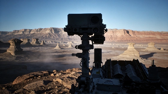
NASA's Curiosity rover has produced its clearest panorama yet of Martian yardangs while climbing Mount Sharp toward a rock layer that may preserve evidence of ancient water, evaporated brines and volcanic ash.
Curiosity has reached the kind of geological boundary that can change the questions a Mars mission asks. A six-image panorama from the rover's Mastcam shows wind-carved cliffs called yardangs in unusually fine detail, offering scientists a closer look at a layer whose origin is still unresolved.
The scene was recorded at 8:30 a.m. local Mars time on Aug. 11, 2026, during Curiosity's 4,982nd Martian day. The foreground carries blue tones because the image was processed without the white balancing normally applied to many Mastcam pictures, preserving more of the scene's early-morning appearance rather than presenting a standardized color balance.
This is a processed panorama rather than a single exposure. Mastcam captured six individual images that were later stitched together after transmission to Earth. The camera recorded reflected sunlight from the landscape; it did not directly measure the composition or age of the yardangs. Those questions will require observations from several instruments and eventually measurements made much closer to the cliffs.
The yardang-bearing unit stretches about 16 kilometers across the northwestern reaches of Mount Sharp. The mountain rises roughly 5 kilometers above the floor of Gale Crater, and its stacked rocks preserve a record of changing conditions on ancient Mars. NASA's rover has now climbed about 1 kilometer above its starting elevation on the crater floor, a measure of the scale of the ascent rather than the mountain's total height.
Curiosity's earlier work on Mount Sharp has linked some layers to lakes and streams that existed billions of years ago. As the water disappeared, salty minerals remained. Later, after fresh sediment stopped accumulating, wind may have removed less-resistant material and sculpted the remaining rock into elongated ridges and crags. The resulting landscape is therefore a record of both deposition and erosion, not simply a set of isolated cliffs.
That explanation is plausible but incomplete. The yardang layer appears to differ in color from nearby rocks, its strata tilt at an unusual angle, and its contact with the mountain can look sharply defined. Ash deposited by ancient volcanic eruptions is one proposed explanation, but the panorama alone cannot distinguish volcanic material from other possibilities or establish how the unit formed.
In August 2026, Curiosity also confirmed from the surface a regional erosional boundary previously identified in orbital observations. The feature, known as an erosional supersurface, separates older and younger deposits within Mount Sharp's sulfate-bearing succession. Crossing that boundary gives scientists a stratigraphic reference point for comparing rocks formed before and after a major episode of erosion. A surface geology report described the boundary and the rover's subsequent sampling activity.
Curiosity's ascent has continued through layers enriched in sulfates and carbonates. These minerals are associated with periods when surface conditions became drier, although their presence alone does not reconstruct the full climate history or prove that the same processes affected every part of Mars. ESA's comparative studies of Martian geology likewise treat mineral context, stratigraphic position and water history as connected but distinct lines of evidence.
The rover is expected to reach the base of the yardangs sometime in 2027. If it does, Curiosity's robotic arm could examine the rocks at close range and collect data unavailable from the distant panorama. NASA's mission planning indicates that the arm may be used for sampling once the vehicle reaches the base of these features, allowing investigators to test whether their textures and mineralogy match the interpretations suggested by orbital and Mastcam observations.
After crossing the supersurface, Curiosity prepared its first drilling operation in rock above that regional boundary. The mission characterizes the operation as the first sample taken from this part of the geological sequence. Small, disk-shaped mineral structures were also observed in the new area. Their form is compatible with crystals that can develop during the slow evaporation of an ancient brine, but that interpretation remains provisional until chemical and mineralogical measurements from the drilled material are available.
At the Basque Lakes location, Curiosity followed drilling with a circular panorama of the surrounding geology. Its ChemCam instrument examined the drill hole, nearby bedrock, sand ripples and separate gray fragments whose origin remains unknown. This combination illustrates the rover's field method: Mastcam documents shape and layering, while ChemCam adds compositional measurements that can test whether visually similar surfaces formed through the same process.
By Aug. 30, 2026, Curiosity had completed its 5,000th Martian day. The rover marked the milestone near a sand ridge informally called Chocolatal, using its navigation cameras to record the surrounding terrain. The achievement is operational as well as symbolic: a mission designed for a prime investigation has continued long enough to trace a broad vertical and temporal sequence through Gale Crater's central mountain.
The image establishes the scale and accessibility of a target that scientists have been approaching for years. It does not yet reveal whether the yardangs formed mainly through wind erosion, whether the layer began as volcanic ash, or how the unit fits into Mount Sharp's broader sequence of deposition and removal.
That distinction matters because a landscape photograph can expose structure without resolving origin. The strongest interpretation will come when Mastcam's visual record is combined with Curiosity's other observations and direct robotic-arm measurements. NASA's broader effort to turn unusual planetary surfaces into testable mission questions is also reflected in earlier lunar research, where surface material was studied for both its composition and its practical significance.
Curiosity's approach therefore represents a scientific handoff from remote reconnaissance to field geology. The panorama is already a substantial result because it identifies the target's geometry and reveals why the layer is difficult to classify, but it is not a solved geological history. The decisive evidence should come from the rocks themselves if the rover reaches them in 2027. That evidence will be evaluated through the same emphasis on mineralogical identification, stratigraphic relationships and reproducible instrument measurements expected in peer-reviewed planetary science, including work reported in Nature.
In planetary imaging, color is evidence only when its processing is understood. Mastcam data can be balanced to approximate a familiar terrestrial view or left closer to the illumination recorded at the Martian surface, as in this panorama. Either choice preserves useful information while changing what the eye emphasizes, so the blue foreground should be read as part of the image's lighting and processing context rather than as a direct map of mineral composition. That restraint is precisely what makes this panorama scientifically valuable: it narrows the geological problem without pretending to have finished it.